
Imagery reveals crop health status during crucial growth stages
Blog by: INTENT
Measuring crop health from plant date to harvest can be challenging without seeing it from above. Through real-time satellite monitoring provided by Planet Labs PBC (“Planet”), crop imagery can be analyzed for overall field health, plant vigor, and make it possible to discover in-field patterns before they impact yield. Because Planet’s reliable, high-frequency fleet of 200 satellites provide growers with broad field coverage and productivity insights, working with Planet data was a straightforward choice for IN10T.
Through FarmerTrials and other commercial work, IN10T’s INvision platform integrates and processes imagery for specified fields boundaries throughout the growing season, providing a holistic view of crop health. IN10T clients currently have field trials throughout the United States, Canada, and South America, so working with an imagery provider that can cover hundreds of fields throughout the trial period was a key deciding factor. Historical imagery can be ordered through Planet, which is a distinct advantage for many reasons. These annual crop maps can then be analyzed for past productivity and field health insights, helping farmers and agronomists identify in-field patterns and region-specific trends when planning for next year’s crop.

Planet imagery is integrated into the INvision platform on most test fields.
HOW DOES INVISION INTEGRATE THE IMAGERY?
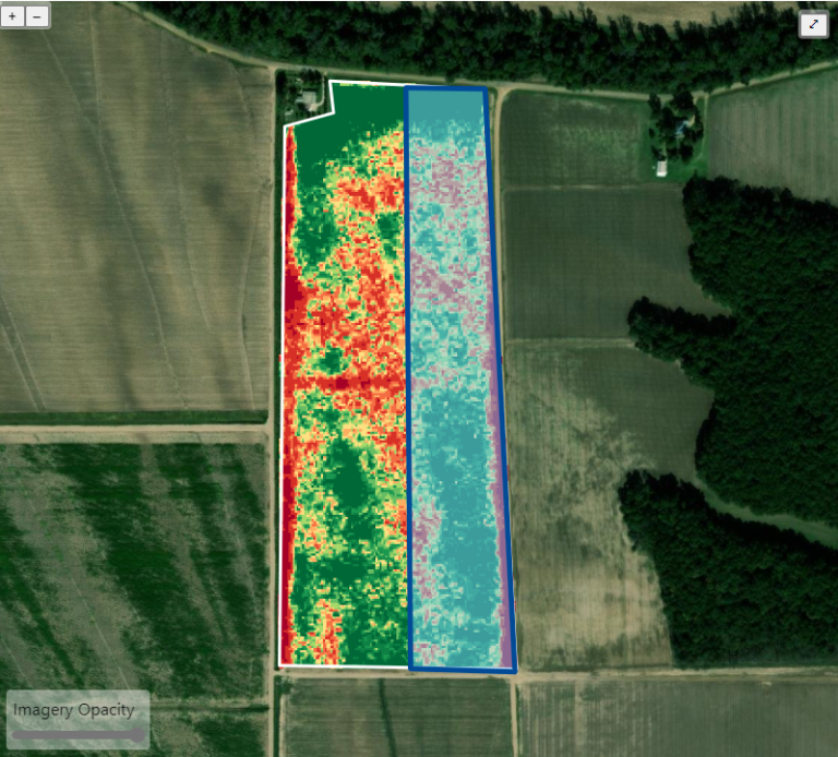
Planting layers or treatment layers can be overlaid on the same imagery within the app.
The INvision portal offers options that make the most sense for each trial, when selecting dates to order imagery. It all happens automatically once the plant date is uploaded to the platform. Depending on each trial protocol, imagery orders can be based on IN10T’s proprietary weather algorithm or crop growth stages. A second proprietary algorithm then analyzes all the images that Planet has available for a specific field, in a certain time range, then automatically and systematically picks the very best image Planet has to offer for that field.
“Once IN10T receives the raw data from Planet, our Plant Health Insights algorithm ties together all the imagery from Planet and delivers it to the INvision platform. Because of the algorithms, this process is virtually hands-free, and doesn’t require much human interaction,” comments Elie Regev, VP of Innovation at IN10T.
Plant Health Insights is our proprietary imagery product that measures an overall and very accurate depiction of field health, revealing changes over the course of the growing season. Out of five to seven images during the week, our algorithm chooses the absolute best image from Planet to integrate into the INvision platform, for clients and farmers to view.
After planting is confirmed for the field, imagery is ordered and automatically scheduled according to the unique growth stage of the crop, and weather information for that area in the country. IN10T is currently providing imagery for most trials three times during the growing season, but that can be customized for individual client needs. These well-timed images can show dramatic changes in plant health. The first image is usually two to three weeks after plant emergence, to pick up early readings. The second image is normally in the middle of the season to see plant vigor and stand establishment, which can sometimes point out differences between treated and non-treated areas in the field. The third image is usually timed right after a final fungicide application, to see the final benefit before the crop is harvested, taken in August before the dry down of the crop takes place.
VALUE AND BENEFITS OF IMAGERY
“Being able to see imagery in context with all the other trial data, planting files, treatment zones, and data we collect with the INFIELD app in one spot, is powerful for the grower and client to see,” states Regev. “Viewing the layers together provides a clear picture of how the crop is progressing in both treated and non-treated areas of the field.”
For clients, satellite imagery provides an early warning system for product efficacy, and can show alarming differences in plant health early on. This provides an opportunity to discover what might be causing issues. Looking at trials in specific areas, was it soil, weather, precipitation, or some other environmental disruption that may be causing problems? Clients can make changes with the trial, without waiting for the final trial results after harvest.
For farmers, satellite imagery integrates with precision agriculture at scale for farms of any size. Imagery early in the growing season can drive decisions to make mid-season nutrient applications, or spot pest or disease infestation problems. Providing broad coverage, field-level detail, and rapid access, Planet imagery offers valuable input at each stage of crop management. It can also help define management zones and, help build variable rate prescriptions for seeding and fertilizer application, which drives planning for next year’s crop. With imagery integrated into INvision, it’s easy to see the entire landscape of how the crop is developing, while also considering the test areas of the field.
IN10T’s goal is to offer visibility and consistent high-quality data throughout the growing season in each trial to our clients and farmers. Our unique approach brings together all aspects of a farmer’s production process into a scalable system that allows us to process data and deliver useful insights with even more speed and agility, which is crucial in the ever-changing ag environment.